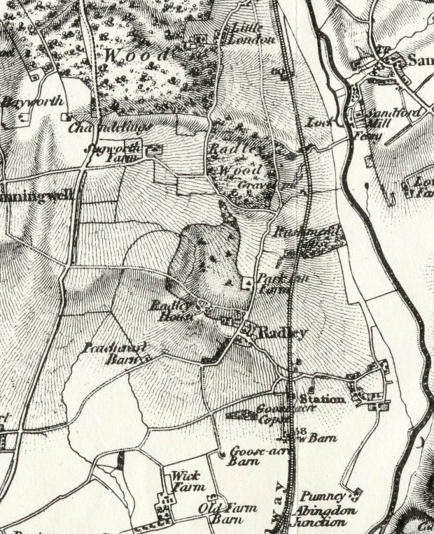
Rocque’s map of 1761 shows an incomplete landscape design which predates Brown’s employment. A reconstruction of his work for Sir William Stonhouse needs to take into account the materials he had to work with and the changes he may have made to the existing design. Subsequent changes include those which happened as a consequence of the separation of the house from the Park when occupied by different tenants, and the introduction of the railway which changed the primary access to the estate. Evidence comes from a series of watercolours and sketches made by William Turner in 1789 and from the official maps surveyed in 1830, 1842 and 1914. In addition, the earliest photographs of Radley College, taken in the 1850s show some elements of the landscape before extensive building after the school acquired the freehold of the site in 1888. The most significant recent change was the construction of the golf course in the 1980s. Finally, recent field survey of the estate indicates the location or survival of Brownian and pre-Brownian features. >>>Rocque’s Map of Berkshire, 1761>>>
In 1789, 14-year old William Turner was studying architectural drawing with his uncle, who lived in Kennington. William was set an exercise in accurate perspective drawing. His sketches and watercolours of Radley Hall and its lodges are the earliest record of the house and grounds after Capability Brown worked on the landscape.

Radley Hall from the south. William Turner, 1789. Originals are in the Tate Gallery. This is taken from a copy made for Radley College in the 1940s
View to the south: ha-ha
Turner’s view of the south front appears to show a curving ha-ha surrounding the house close in. This is not visible on Rocque’s map of 1761 and is not shown on the 1842 tithe map. It doesn’t allow room for a drive and turning circle, which appear on the 1830 OS map; this implies that it was a relatively short-lived feature. This is the side facing G Social Patch and Peachcroft. Rocque’s map shows this area laid out as formal gardens. These had clearly been swept away by 1789. Although Capability Brown did not invent the ha-ha, he often used them as key design features. The ha-ha allowed an uninterrupted view towards the Berkshire Downs whilst protecting the area closest to the house from deer or sheep in the Park. The sheep grazing in an idyllic landscape to the south of the house feature as a selling point for the prospectus of Radley Hall School in 1830.

Prospectus for Radley Hall School, 1830. © Radley College Archives
The north front: from formal avenues to natural landscape, clumps and shelter belts
The north front faced the park. Rocque’s map shows an avenue leading directly from the main door, across the park, and eventually becoming a footpath heading towards Kennington and Sugworth.

Rocque’s map, 1761. Detail
Turner’s view of the north front shows a drive coming to the front door with a few scattered trees in clumps or groves. He also shows a wall with railings enclosing the south garden but not the north front. The view to the south to the Berkshire Downs is also clear. The building in the trees to left (east) does not appear on Rocque’s map, but is visible on the 1842 tithe map, and is probably part of the offices which were later incorporated into what is now F Social.

Turner, 1789. Radley Hall north side. Originals are in the Tate Gallery. This is taken from a copy made for Radley College in the 1940s
The 1st ed Ordnance Survey map of Berkshire and Oxfordshire published in 1830 shows how the drive worked, with a path coming down from Cheesers, across the park, looping in front of the north side of the house and then picking up the path that is now the front drive.

1st edn OS Berkshire & Oxfordshire 1830
Turner’s sketch straight onto the north front shows that the formal avenue shown on Rocque’s map has been swept away and typical Brownian clumps left in their place. The 1830 OS map shows clumps of trees dotted across the Park, although this may simply be a way of indicating parkland. Jackdaw Clump and Dormitory Clump (now felled) were both sited exactly on a line from the front door of the Mansion, and in origin are probably parts of the earlier avenue which Capability Brown left in place rather than planting new trees.

Turner 1789. Radley Hall from the north. Originals are in the Tate Gallery. This is taken from a copy made for Radley College in the 1940s
The amount of money raised by Sir William Stonhouse in 1769 for the sale of timber argues for the near complete removal of the trees from both avenues. Removal of avenues was a typical Brownian design feature. Neither the 1830 OS map nor the 1842 Tithe map show an avenue running down from Cheesers. In both cases the path is clear running from the old toll road across pasture and park. In 2016, the avenue of Cheesers consists of a few very old sweet chestnuts near the entrance from the toll road, which may date from the early 18th century, an avenue of trees given by Edward VII in the 1900s, proceeding up the hill from College Oak and its companion oak tree near the stream called Kishon to the edge of the Park, and an avenue of different varieties of oak trees connecting the two, planted by Hugh Cardwell in the 1960s. The aerial photo taken in 2015 shows the length of Cheesers almost as it must have been in 1761, and indicates the magnitude of the task facing Capability Brown as he reduced the avenue to picturesque clumps.
>>more>>>Loss & Rediscovery: Capability Brown’s landscape at Radley
